How did Joan Park get its name?
Sitting inconspicuously at the end of Richard Avenue in Lindsay, near the corner of Angeline Street North and the new Connelly Road, is a green space known as Joan Park. It’s nothing more than grass surrounded by trees. No flowers. No playground equipment. No sign to mark its location. How long has it been there and who was Joan?
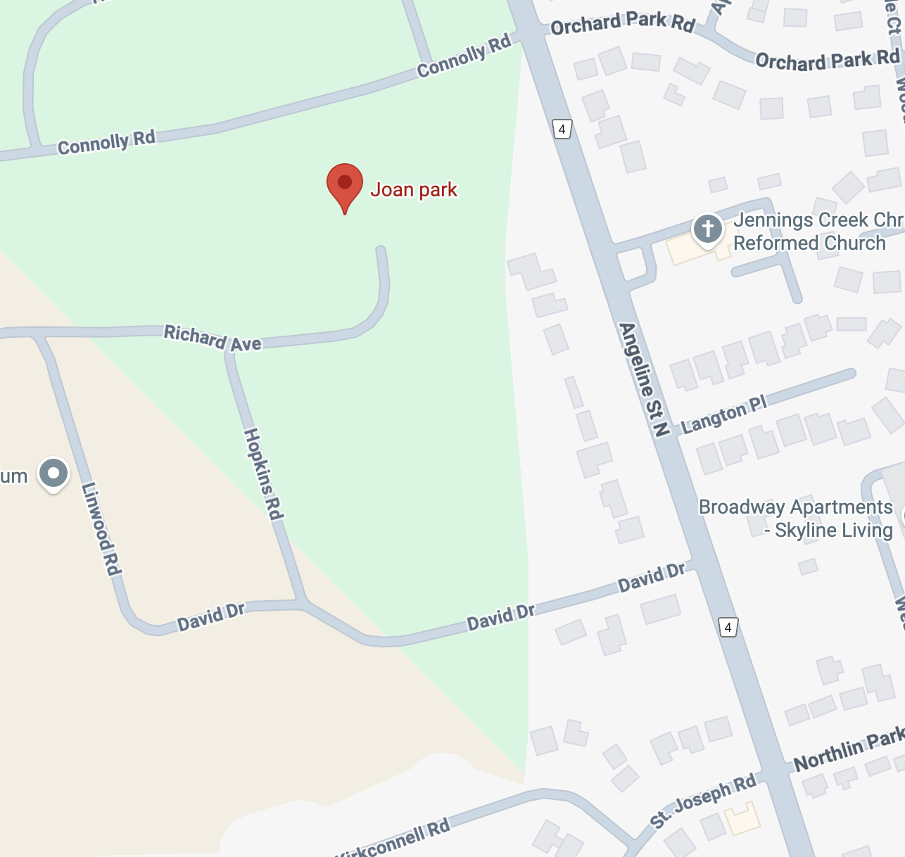
Image © Google.
New Subdivision
Nearby streets give us some clues: Richard Avenue, Hopkins Road, Linwood Road, David Drive. These streets and Joan Park were part of the same subdivision that began in August 1959 with the development of these roads on 22 acres that spanned from Angeline to Highway 35. The property included a barn, proof of its pioneer origins. The company, Fenroad Developments (likely named after the former name of Angeline Street: Fenelon Road), had plans for 46 homes ranging in price from $13,000 to $18,000 to be built in this subdivision they called Linwood Heights.
At the time of development, the area was outside of the limits of the Town of Lindsay, but within the area proposed to be annexed. There were no town services; water was by wells and sewage was handled by septic tanks. For two years after the subdivision was formally annexed, the six residents didn’t have access to the town’s services of garbage disposal, snow plowing, police and fire protection. Because they were no longer part of Ops township, they didn’t have services provided by the township, either. It wasn’t until May 1962 that the town agreed to provide full services.
New Park
The area of the park was left undeveloped for a number years, even after it was acquired by the town as part of its 5% parkland levy. In 1966, the Anglican Church offered to buy part of the park. The town agreed with two conditions: 1) if the land was not developed within ten years, it would be returned to the town for the amount paid, $2000, and 2) if the land was put up for sale before the ten years were up, the town would have the first opportunity to buy the land. The town was hoping to use the money to buy other parkland, but the Anglican Church turned down the offer. For the next three years, the town tried to sell the land, but no deal stuck.
In 1977, a road was proposed to go through the park, but local citizens filed a petition to stop the road. Further, they requested the park be cleaned up and play equipment added for children. Nothing was done about this request, and by 1983, another appeal was made for work on the park. This time, the request was successful. Using funds from the Roy Wilson Endowment, the park was patched up but left in a natural state, as requested by the citizens. The park has remained in the same condition since, although it appears a new road may be bisecting the park. Perhaps the street will return to its previous name, Joan Park Road.
Linwood Heights Owners
The owners of the Linwood Heights subdivision were Mr and Mrs Milford Sleep. At the time of the construction, the Post reported Milford Sleep was a partner at Lincraft Ltd. Mrs. Sleep was the daughter of Richard Hopkins. Her grandfather was well known in Lindsay. The Lindsay Post quotes Mrs. Sleep as saying her grandfather drew the blueprints for the courthouse (now city hall) that she still had in her possession, however, Hopkins’s name does not appear on the blueprints. The architects were Cumberland and Storm with John Kestevan as contractor, the same team that planned and constructed the Lindsay jail, which is now our museum.
A deeper dive into the genealogy of this family gives us a little more information.
The Sleep Family
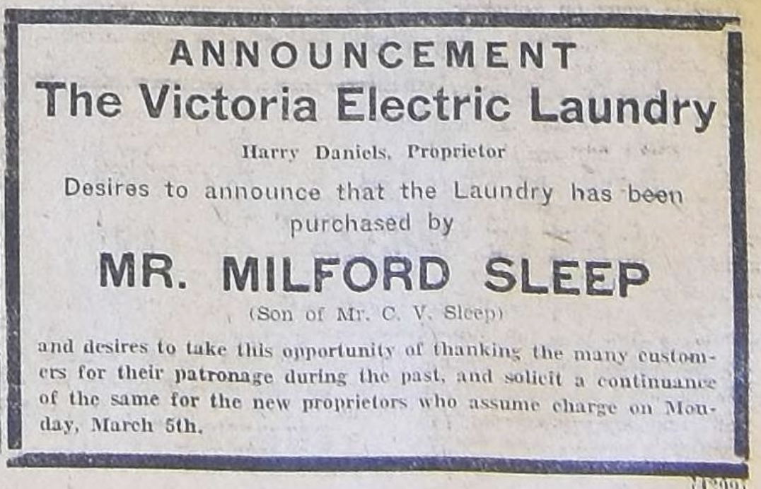
Charles Milford Sleep was born 1914 to parents Cecil Victor Sleep and Elva Beadle. In 1934, Milford Sleep purchased the Victoria Electric Laundry located at 98 Russell Street West, which included both the house and the laundry factory behind it. At some point, he married Marion Hopkins, possibly in the late 1930s to early 1940s. Until 1965, Milford was a member of the Parks board, when he moved outside of Lindsay. This is likely when he relocated to the Hopkins farm, which was beyond the town limits in the former Ops township.
The Hopkins Family
Marion Louise Hopkins was born around 1916. In 1924, her letter to Santa appeared in the Lindsay Post. She was 8 years old and her Christmas wish was for a big doll buggy, a pair of galoshes, and a hanky. She was the only child of Richard Hopkins and Mabel Martha Henderson.
Marion’s grandfather was Col. Eustace Holmes Hopkins, who was born in England and came to Canada at age 8. He settled in Lindsay, where he became active in politics and military service. He lived for many years at the corner of Mill and Russell streets. For three years in the 1870s, he was a member of town council, and then was a member of county council for about 14 years. It was likely during this time that he acquired a set of blueprints of the courthouse. He joined the 45th regiment when he was 20. He married Ellen Dever and had four children: Richard, Herbert, Edward and Edith.
The Source of the Street Names
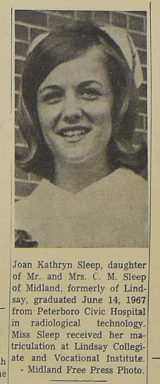
Milford and Marion had a son, David, who was badly injured in 1963, with friends expressing concern in the Lindsay Post. Around that same time, there was a girl named Joan Sleep in Lindsay, and she was listed with the school activities reported in the paper. A little further digging confirms this is Joan Kathryn Sleep, daughter of Mr and Mrs C. M. Sleep, as reported in the July 3, 1967 edition of the Lindsay Post, when she graduated from nursing school. This discovery leads to Joan’s obituary, which further tells us she had two brothers, Richard and David, and married George Oliver. She passed away in 2016.
It appears Milford and Marion lovingly named the streets of Linwood Heights in honour of their family members: Richard Hopkins, Richard Sleep, David Sleep and the Linwood Heights business venture.
And as for Joan Park? It was named for Joan Kathryn Sleep: